PROPOSED RESERVE PATHWAYS IN NEPEAN
Dr. John Walker
There is an opportunity to establish a legacy multi-user pathway network in the former city of Nepean. Currently, there are significant unused greenspace corridors, such as the one extending from Baseline Station, southwards along the west side of Woodroffe Avenue and then traversing eastwards along the CN Rail Corridor to the Rideau River. In addition, there are also attractive green spaces that are underutilized by the general public, such as along the southern part of the Rideau River which have recreational and cycle tourism potential. It is proposed that these greenspace corridors be made more available to the public via a recreational pathway through them that links with other pathways so that more citizens can readily enjoy the areas.
This document proposes four pathway systems that makes use of existing right-of-way corridors that connect to already established pathways: 1) Colonnade-CN Corridor Connector (Woodroffe to Prince of Wales Drive), 2) South Rideau River pathway (western side to Long Island), and 3) the Jock River loop pathway. A fourth connection along the west side of Mooney's Bay between Prince of Wales Drive and Hogs Back road is also suggested.
Preliminary estimates suggest that the three projects would cost about $2 million. Together with the other recreational pathways in Nepean and surrounding regions, these new paths open a number of interesting and scenic loops for the casual and recreational users as well as some new routes for commuters.
1) Colonnade-CN Corridor Pathway Connector
From: Woodroffe at Norris
To: Prince of Wales south of Fisher
Length: 3 km
Preliminary Estimate of Cost: $150,000
This east-west recreational pathway would extend from the controlled intersection of Woodroffe at Norice and follow the CN right-of-way greenspace corridor from Woodroffe to Merivale Rd. and then follow the corridor parallel to Colonnade Rd. North as far as Prince of Wales Drive, just south of Fisher. To cross Merivale Road, the pathway would be routed to the light on Merivale at Colonnade. The western end of the proposed network connects with the Capital Pathway that ends at the Baseline Transit Station. Links to the communities to the north and south of the pathway would be needed to provide connections to the neighborhoods of Tanglewood and Crestview and Meadowlands.
It is suggested that landscaping, such as cedar trees, be planted along the railway and around the Hydro station to reduce the noise and improve the splendor of the pathway. The pathway might also be enhanced with low maintenance flowering shrubs and roses bushes and a few benches.
The recreational path would continue onto the eastside of Merivale and link up with the new pathway in Nepean Park. This path follows along the south side of Nepean creek down by some ponds and dams and then curves to join Colonnade N. It is proposed that a link be built over Nepean Creek to the controlled junction of the Prince of Wales Drive and Fisher Ave. so that cyclists can complete a loop via Hogs Back with the aid of the paved shoulders on Prince of Wales. The terrain is steep and the pathway would require some grading but there is a footpath and a bridge to cross the creek to the junction. There should be links to Viewmount Park and Valley Ridge from the pathway. The length of this pathway is about 3 km and at $50 a metre would cost about $150,000. The shoulders of Prince of Wales Highway are paved so that cyclist could travel north towards Hogs Back Road, which has links along the canal to Carleton University and along the Rideau River to the office complex at Confederation Heights. Cyclists could return along the Capital Pathway by the Experimental Farm or continue down to Parliament Hill and return along the Capital Pathway beside the Ottawa River.
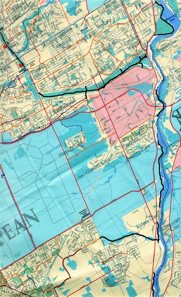
The proposed pathway is shown in black on the Ottawa-Carleton Cycling map 2000 below.
2) South Rideau River Pathway (western side to Long Island)
From: Hogs Back Road to Long Island
Length: 14 km
Preliminary Estimate of Cost: $ 300,000.
Ideally, it would be most pleasant for cyclists and other users if there was a continuous path all the way along the west side of the Rideau River from Hogs Back Road to Long Island and Manotick. However, there are numerous homes along the route that have access down to the river and there are also some stretches where it would be difficult to construct a path near the river. Thus, some parts of the Rideau Pathway would have to use the shoulders of the Prince of Wales Highway. Most of these shoulders are paved but some stretches would need to be upgraded.
The first stage of the Hogs Back to Manotick pathway should be to establish a link around the Moffet Farm west of Mooney's Bay. There is a presently a lane that crosses most of the farm so initially a link from just west of the Rideau Canoe Club then around Nesbitt Point, if possible, and across a creek to Melfa Crescent then along the shore to this existing lane would be adequate. The Farm is under negotiation with the NCC but a strip along the shore at least 50 m wide should be retained for public use as it is on a bluff and attractively forested. Hence, a future pathway should continue on this bluff around to the Prince of Wales Highway and should be developed by the NCC and the city of Ottawa. It is nearly 2 km long and would cost about $100,000. This pathway would then provide a nice extension to the paths along the canal and the Rideau River as well as a link to the new path by Nepean Creek and the proposed extension to Woodroffe, which has a link to the Capital Pathway at the Baseline Transit Station.
It appears possible to have a short loop under the Hunt Club Bridge and this could be explored. However most of the homes along this section of the river appear to have land down to the water so it would be difficult to build a pathway here. Nevertheless an inquiry could be made to ascertain the availability of a narrow strip along the edge of the river. The next stretch of accessible river is that just south of Country Place. It should be possible to have about 2 km of pathway that could link up with the locks at Black Rapids and then with the north end of Glen Drive. It is a very nice country stretch and should have a bench or viewing platform near the creek at Fallowfield. An artificial beach with a change and washroom facility should be explored for this section. The path should then continue from Holborn Ave. to Winding Way.
The Rideau Valley Conservation Authority has developed a very attractive pathway and boardwalk with several viewing platforms on the new Chapman Mills Conservation Area between the south end of Winding Way and Lodge Road. There is also a parking area, kiosk, picnic shelter and canoe launch at the north end of the conservation area. However, the boardwalk is not suitable for cycling and a stretch of about 0.6 km would be needed to link the RVCA stonedust pathways. A short part has a steep gradient and armour stone would probably be required for its construction. Mr. C. Craig of the RVCA indicated the agency would be pleased to work with those interested in such a pathway through the conservation area. The Collins Heritage house is just across the highway from the conservation area and would be another attraction for users of the pathway. A preliminary estimate of the cost for this section would be about $50,000.
The Lodge Road ends near where the Jock River flows into the Rideau River and a short path and bridge would be required to take the user onto the new Beryl Gaffney Park. The pathway should progress along the west branch of the Rideau River up to Lockview Rd and Barnsdale Rd where there is a bridge to Long Island. The total length of this segment is about 4 km and would cost at least $300,000 including three bridges. There should also be a link to Nicolls Island, which has a bridge to the eastside of the Rideau River, locks and a dam but no public access to Manotick Island. Hence, those on the eastside of the river would have access to the Rideau Pathway by these two links. A path on Long Island Park leads to Long Island road, which takes one to Bridge St. and over the bridge is Mill St., the Dickinson Square Conservation Area and the lovely historic Watson's Mill.
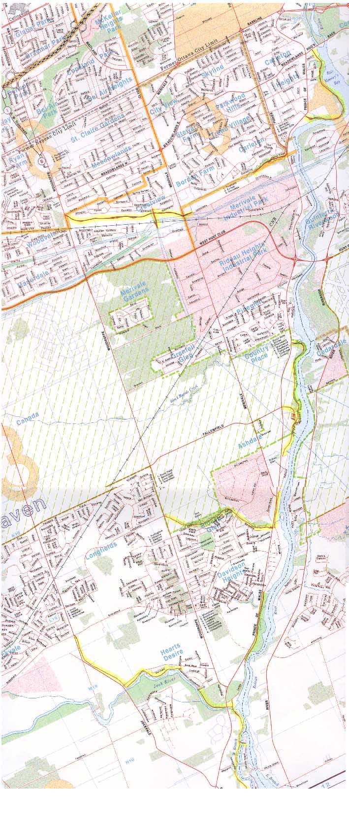
The proposed pathway is highlighted on the Ottawa Urban map shown below.
3) Jock River - Barrhaven Pathway
Jock River Leg: Along Jock River from Prince of Wales at Lodge Rd. to Greenbank Rd.
Barrhaven Leg: Along Berrigan and Longfields from Greenbank to Woodroffe
Rideau Glen Leg: Through the Greenbelt from Woodroffe to Prince of Wales at Winding Rd.
Length: 5 km
Preliminary Estimate of Cost: $250,000
A link to Barrhaven should be along the creek that extends to the Rideau River at Winding Way. It should follow the creek up to Sach's Forest and onto Longfields Drive. This section is about 2 km long and a preliminary estimate of the cost is about $100,000. The pathway then follows along to Greenbank Road and then to the Town Centre. It should then follow Jockvale Rd. or the transit corridor down to the conservation area on the south side of the Jock River and along it to a bridge over the Jock River and onto Goodwood Drive. The path then continues through Heart's Desire Forest and under the Prince of Wales Highway to the Rideau Pathway, thus forming a loop for the residents of Barrhaven and others with pleasant scenery. The length of this loop is about 3 km and a preliminary estimate of the cost would be about $150,000. Signage at several locations along the pathway should indicate where the traveler is at and other pathways.
The Rideau River is fairly wide near the Fallowfield junction and it might be possible to have a small park with an artificial beach in this region. Such a facility would be readily accessible to the residents of Barrhaven, Country Place and those in eastern Nepean. A shallow cove and beach for children might be part of the park and such possibilities should be explored. A road, parking lot and artificial beach with a change and washroom facility might cost $300,000.
Next Steps
The total length of the new pathway is about 16 km. At an estimated cost of $50 per meter for the pathway and with a beach, park, land and several bridges, a preliminary estimate of the total cost total would be about $2 million. It is recommended that this proposal be referred to staff for review and more refined planning work and construction estimates. An environmental study might be necessary for some parts of the pathway and eventually detailed plans. Some land may also have to be acquired for some sections and hence the cost may be somewhat more. Most of the plan is consistent with the Official Plan of the Region of Ottawa-Carleton. However, the section around Moffet Farm is not, as the Official Plan calls for a bridge across the Rideau River and the pathway continuing on the eastside of the river. Such a bridge would be expensive as the river is fairly wide and the path does not provide a direct route for Nepean residents to get to other links along the Rideau River or to Carleton University and Confederation Heights. The Official Plan does not indicate a pathway from Winding Way into Davidson Heights but a commuter route on the proposed Standherd Drive and bridge over the Rideau River. Such a route would not be as scenic or pleasant and would be of limited use to most residents of Barrhaven. It is suggested that an exploratory study be undertaken to more accurately determine the feasibility and cost of the project.
![]() Call
John at 613-224-3570 for discussion. Thanks
for dropping by.
Call
John at 613-224-3570 for discussion. Thanks
for dropping by.